← Home · Foundations

Raft and Mat Foundation Design in Bognor Regis

Together, we solve the challenges of tomorrow.

SEE MORE →

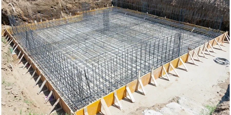
Bognor Regis sits just 5 metres above sea level on the West Sussex coastal plain, where the underlying geology shifts from Brickearth to soft alluvial clays across short distances. The town’s 63,000 residents know the ground here can be unpredictable. A test pit campaign often reveals the first surprises—layers of made ground over compressible silts that rule out conventional footings. Raft or mat foundation design becomes the logical path. We provide that design: a reinforced concrete slab spreading structural loads across a wide area, so differential settlement stays within tolerable limits. By integrating data from CPT testing and laboratory classification, we produce a foundation scheme that fits the site, not a generic template.

A raft foundation doesn't eliminate settlement—it controls it, turning differential movement into uniform tilt the structure can tolerate.

Approach and scope

Bognor’s expansion from a small fishing hamlet into a substantial seaside town means many plots have a hidden history of previous structures or buried service trenches. This legacy affects ground stiffness and continuity. Our raft design process starts with a desk study, then moves to intrusive investigation. We use in-situ permeability data to assess drainage beneath the slab, because trapped water in Brickearth can soften the formation over time. The structural analysis models the raft as a plate on an elastic subgrade, with spring stiffness derived from site-specific modulus values, not textbook assumptions. Where ground variability is high, we stiffen the raft with integral downstand beams, effectively creating a ribbed mat that bridges softer pockets. Direct output includes reinforcement schedules, excavation levels, and subgrade preparation specs aligned with Eurocode 7.
Raft and Mat Foundation Design in Bognor Regis
Technical reference image — Bognor Regis

Site-specific factors

The coastal humidity and shallow groundwater in Bognor Regis create a specific risk for raft foundations: sulphate attack on buried concrete. The underlying London Clay and local Brickearth deposits can contain water-soluble sulphates that degrade standard Portland cement over a decade. Our design specifies sulphate-resisting cement or a protective membrane based on BRE Special Digest 1 soil classification results. A second risk is seasonal volumetric change in the near-surface clay. A raft built too close to ground level can heave in wet winters and settle in dry summers. We set the formation depth below the zone of moisture fluctuation, typically 850 mm to 1,200 mm, and include a compacted granular blanket to break capillary rise. For sites within 500 metres of the seafront, we also account for chloride-induced corrosion risk in the reinforcement cover specification.

Need a geotechnical assessment?

Reply within 24h.

Email: contact@geotechnical-engineering1.com

Technical parameters


ParameterTypical value
Design code basisBS EN 1997-1:2004 + UK National Annex
Subgrade reaction modulus (k_s)Derived from plate load test or CPT correlation, not assumed
Bearing capacity verificationUndrained (short-term) and drained (long-term) per Annex D
Settlement analysis methodElastic half-space or finite element, depending on soil layering
Typical raft thickness range250 mm to 600 mm for residential; up to 1.2 m for commercial
Minimum steel gradeB500B to BS 4449:2005
Improvement integrationCompatible with vibro stone columns or rigid inclusions if needed
Durability exposure classTypically XC2 (wet, rarely dry) for buried slabs in coastal Bognor

Related technical services

01

Ground Investigation Specification

We specify boreholes, CPTs, and trial pits to capture the lateral variability across the Bognor Regis site, ensuring no soft spot is missed before raft design begins.

02

3D Finite Element Raft Analysis

For complex footprints or mixed-load scenarios, we model soil-structure interaction in 3D to optimize slab thickness and reinforcement layout.

03

Settlement and Heave Assessment

Detailed calculations of total and differential settlement under service loads, plus seasonal heave prediction for raft foundations on desiccated clay profiles.

04

Construction Support and Subgrade Verification

Site visits during excavation to confirm design assumptions against exposed ground conditions, plus plate load testing to validate bearing capacity.

Relevant standards


BS EN 1997-1:2004 (Eurocode 7: Geotechnical design), BS 8500-1:2015 (Concrete – Complementary British Standard), BRE Special Digest 1:2005 (Sulphate attack)

Common questions

When is a raft foundation better than deep piles in Bognor Regis?

When the competent bearing stratum is deeper than 3 metres but the soil above has enough stiffness to support a uniformly loaded slab. Rafts avoid the cost and vibration of piling rigs in tight residential streets, and they perform well on soft alluvial clays where total settlement can be managed by spreading the load.

What does a raft foundation design package typically cost?

For a standard residential project in Bognor Regis, the design fee ranges from £910 to £3,770, depending on footprint complexity, number of ground investigation points, and whether 3D finite element analysis is required.

How do you determine the subgrade reaction modulus for the raft design?

We avoid generic tables. The modulus is back-calculated from CPT cone resistance data or direct plate load tests on site. This gives a spring stiffness that reflects the actual layering beneath the Bognor Regis plot, not a regional average.

Can a raft foundation be designed on made ground?

Yes, provided the made ground is properly characterized. We often encounter old beach shingle or brick rubble fill in Bognor. If the fill is granular, well-compacted, and at least 2 metres thick, a stiffened raft can work. If it contains organic silts or uncompacted ash, we recommend excavation and replacement before raft construction.

What information do you need to start the raft design?

A topographic survey, the architectural ground-floor plan with column and wall loads, and the findings from a ground investigation—ideally one borehole or CPT per 150 m² of footprint, plus trial pits to inspect near-surface fill. We can scope the investigation if you haven't commissioned one yet.

Location and service area

We serve projects across Bognor Regis and its metropolitan area.

View larger map