← Home · Geophysics

Seismic Tomography Surveying in Bognor Regis

Together, we solve the challenges of tomorrow.

SEE MORE →

Bognor Regis owes much of its coastal town character to a geology shaped by Cretaceous chalk overlain by Quaternary drift deposits. The historical expansion of the resort, accelerated by the railway arrival in 1864, placed increasing demand on ground investigation as builders encountered buried channels and variable chalkhead. Seismic tomography cuts through that uncertainty. Our team deploys both refraction and reflection arrays across West Sussex sites to map bedrock depth, detect dissolution features and define the transition between weathered and competent chalk. Where granular superficial deposits mask the chalk surface, a seismic refraction survey provides a continuous velocity profile without the interpolation gaps that borehole-only campaigns leave behind. The method works well even in the constrained spaces of seafront redevelopments and residential extensions common across the PO21 and PO22 postcodes.

Velocity contrasts across a dissolution pipe in chalk can exceed 800 m/s over less than 5 metres horizontally — refraction alone will miss that unless the spread geometry accounts for it.

Approach and scope

Bognor Regis sits at roughly 7 metres above mean sea level, with groundwater perched within the raised beach and brickearth deposits that drape much of the town centre. 56-shot refraction spreads with 2-metre geophone spacing resolve layering down to 30 metres depth — sufficient to capture the chalk rockhead and any infilled palaeochannels. Reflection profiling extends that reach to 80 metres. We process data with tomographic inversion rather than simple intercept-time methods, which matters where lateral velocity gradients are steep. Complementing the velocity model with an MASW survey yields small-strain shear modulus values for foundation design. The equipment runs 24-bit recording with 0.125 ms sampling, synchronised via GPS timing for consistency across multiple spreads. Data are referenced to BS 5930:2015+A1:2020 logging standards so that seismic boundaries align with geotechnical descriptions from any follow-on boreholes.
Seismic Tomography Surveying in Bognor Regis
Technical reference image — Bognor Regis

Site-specific factors

Around Bognor Regis we repeatedly see boreholes that terminated prematurely in a flint-rich band, misidentifying it as chalk rockhead. Seismic refraction catches this because the velocity of flint concentrations sits well below that of intact chalk. Relying on probe refusal alone leads to underestimated pile lengths and later claims. Another local hazard is dissolution piping within the Lewes Nodular Chalk Formation. These features create sharp velocity lows that standard grid drilling can miss entirely. A dense seismic line with tomographic processing reveals the lateral extent of softened zones before excavation starts. The risk is not theoretical — several coastal defence and apartment developments between Aldwick and Felpham have required redesign after discovering karstic voids late in the programme. A single day of seismic acquisition can prevent that.

Need a geotechnical assessment?

Reply within 24h.

Email: contact@geotechnical-engineering1.com

Technical parameters


ParameterTypical value
Survey methodSeismic refraction and high-resolution reflection
Typical penetration (refraction)15-30 m below ground level
Typical penetration (reflection)Up to 80 m below ground level
Geophone spacing1-5 m depending on target resolution
Recording system24-bit seismograph, 0.125 ms sampling
Source typeAccelerated weight drop or sledgehammer on plate
Applicable standardBS 5930:2015+A1:2020, Eurocode 7 (BS EN 1997-1:2004)
Deliverable2D velocity cross-sections, depth-to-rock maps, tomograms

Related technical services

01

Seismic Refraction Tomography

Refraction profiling with first-break picking and tomographic inversion. Delivers 2D velocity sections for bedrock mapping and rippability assessment across Bognor Regis sites.

02

High-Resolution Seismic Reflection

Multi-offset reflection acquisition for deeper targets. Useful where the chalk cover exceeds 30 metres or where fault throw must be quantified.

03

Combined Seismic-MASW Survey

Simultaneous acquisition of refraction and surface-wave data on the same spread. Provides both P-wave and S-wave velocity profiles for dynamic soil stiffness parameters.

Relevant standards


BS 5930:2015+A1:2020 — Code of practice for ground investigations, Eurocode 7 — BS EN 1997-1:2004 Geotechnical design — General rules, ASTM D5777-18 — Standard Guide for Using the Seismic Refraction Method

Common questions

What does a seismic tomography survey cost for a typical Bognor Regis site?

For a single refraction line with 24 to 48 geophones, costs in the Bognor Regis area generally range between £2,030 and £4,610. The final figure depends on spread length, access constraints and whether reflection lines are added. We provide a fixed-price proposal after reviewing the site plan.

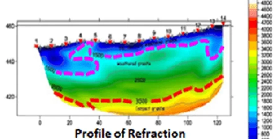
How deep can seismic refraction reach in the chalk around Bognor Regis?

With a 115-metre spread length and an accelerated weight drop source, refraction reliably images to 25-30 metres depth in the local chalk sequence. Reflection profiling extends that to 80 metres, which is sufficient to map the transition to the West Melbury Marly Chalk Formation and any major faulting.

Do you need traffic management to run a seismic line on a Bognor Regis road?

It depends on the location. For quiet residential streets in PO21 we can often work with basic signing and banksmen. On busier routes near the A29 or seafront, a formal traffic management plan and permit from West Sussex County Council may be required. We handle that coordination as part of the mobilisation.

Location and service area

We serve projects across Bognor Regis and its metropolitan area.

View larger map